
Topografische Karte Mo’orea
Interaktive Karte
Klicken Sie auf die Karte, um die Höhe anzuzeigen.
Über diese Karte
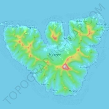
Name: Topografische Karte Mo’orea, Höhe, Relief.
Durchschnittliche Höhe: 86 m
Minimale Höhe: 0 m
Maximale Höhe: 1.202 m
Many Moʻorean endemic species that have gone extinct or been extirpated. The Polynesian tree snails of the genus Partula were largely wiped out after the rosy wolf snail was introduced in 1977, although captive and small refuge populations on Tahiti still exist. In 2019 the Partula rosea and Partula varia were reintroduced to the island. Until the 1980s, the Moʻorea reed warbler, an endemic species, was recorded on the island. This songbird was closely related to the Tahiti reed warbler and may have been displaced by the common myna. Another bird species extinct on Moʻorea is the Moʻorea sandpiper, of which only two specimens are known from 1777. The tree Glochidion nadeaudii is endemic to the island, growing in montane rain forests above 400 meters elevation.
Andere topografische Karten
Klicken Sie auf eine Karte, um ihre Topografie, ihre Höhe und ihr Relief anzuzeigen.
Pāʻea
France > French Polynesia > Windward Islands
Pāʻea, Windward Islands, French Polynesia, 98711, France
Durchschnittliche Höhe: 252 m
Tahiti
France > French Polynesia > Windward Islands
Tahiti, Windward Islands, French Polynesia, France
Durchschnittliche Höhe: 160 m
Faʻaʻā
France > French Polynesia > Windward Islands
Faʻaʻā, Windward Islands, French Polynesia, 98704, France
Durchschnittliche Höhe: 346 m