
Topografische Karte Carmel Bay
Interaktive Karte
Klicken Sie auf die Karte, um die Höhe anzuzeigen.
Über diese Karte
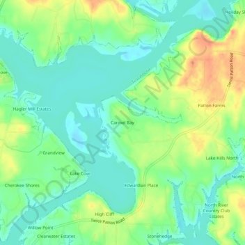
Name: Topografische Karte Carmel Bay, Höhe, Relief.
Ort: Carmel Bay, Tuscaloosa County, Alabama, 35475, United States (33.35704 -87.60231 33.39704 -87.56231)
Durchschnittliche Höhe: 82 m
Minimale Höhe: 65 m
Maximale Höhe: 110 m
Andere topografische Karten
Klicken Sie auf eine Karte, um ihre Topografie, ihre Höhe und ihr Relief anzuzeigen.
Tuscaloosa
United States > Alabama > Tuscaloosa County
Tuscaloosa, Tuscaloosa County, Alabama, United States
Durchschnittliche Höhe: 98 m
Little Sandy
United States > Alabama > Tuscaloosa County
Little Sandy, Tuscaloosa County, Alabama, United States
Durchschnittliche Höhe: 72 m
Bull City
United States > Alabama > Tuscaloosa County
Bull City, Tuscaloosa County, Alabama, United States
Durchschnittliche Höhe: 161 m
Northbrook
United States > Alabama > Tuscaloosa County > Northport
Northbrook, Northport, Tuscaloosa County, Alabama, 35476, United States
Durchschnittliche Höhe: 70 m
Peach Grove
United States > Alabama > Tuscaloosa County > Tuscaloosa
Peach Grove, Tuscaloosa, Tuscaloosa County, Alabama, 35405, United States
Durchschnittliche Höhe: 109 m
Coker
United States > Alabama > Tuscaloosa County
Coker, Tuscaloosa County, Alabama, United States
Durchschnittliche Höhe: 68 m
East Lake
United States > Alabama > Tuscaloosa County > Tuscaloosa > East Lake
East Lake, Tuscaloosa, Tuscaloosa County, Alabama, 35405, United States
Durchschnittliche Höhe: 110 m
Northport
United States > Alabama > Tuscaloosa County > Northport
Northport, Tuscaloosa County, Alabama, United States
Durchschnittliche Höhe: 89 m
Brookwood
United States > Alabama > Tuscaloosa County
Brookwood, Tuscaloosa County, Alabama, United States
Durchschnittliche Höhe: 150 m