
Topografische Karte San Juan Bautista
Interaktive Karte
Klicken Sie auf die Karte, um die Höhe anzuzeigen.
Über diese Karte
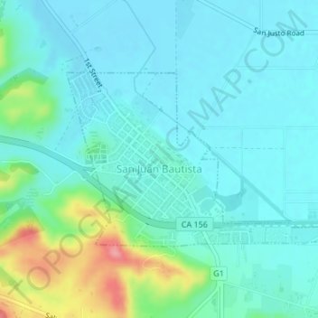
Name: Topografische Karte San Juan Bautista, Höhe, Relief.
Durchschnittliche Höhe: 72 m
Minimale Höhe: 50 m
Maximale Höhe: 158 m
In June 1904, early aviation pioneer John J. Montgomery made a series of successful test flights using his tandem-wing glider in San Juan. This was a prototype to his 1905 gliders that were used to make the first successful high-altitude flights in heavier-than-air flying machines in the world.
Andere topografische Karten
Klicken Sie auf eine Karte, um ihre Topografie, ihre Höhe und ihr Relief anzuzeigen.
Pinnacles National Park
United States > California > San Benito County
Pinnacles National Park, San Benito County, California, United States
Durchschnittliche Höhe: 495 m
Llanada
United States > California > San Benito County
Llanada, San Benito County, California, United States
Durchschnittliche Höhe: 490 m
Paicines
United States > California > San Benito County
Paicines, San Benito County, California, United States
Durchschnittliche Höhe: 237 m
Hollister
United States > California > San Benito County
Hollister, San Benito County, California, 95023, United States
Durchschnittliche Höhe: 92 m
Laguna Mountain
United States > California > San Benito County
Laguna Mountain, San Benito County, California, United States
Durchschnittliche Höhe: 1.131 m
Fremont Peak State Park
United States > California > San Benito County
Fremont Peak State Park, San Benito County, California, United States
Durchschnittliche Höhe: 705 m
High Peaks
United States > California > San Benito County
High Peaks, San Benito County, California, United States
Durchschnittliche Höhe: 565 m