
Topografische Karte Noordwijkerhout
Interaktive Karte
Klicken Sie auf die Karte, um die Höhe anzuzeigen.
Über diese Karte
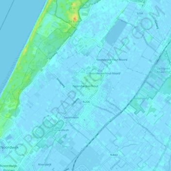
Name: Topografische Karte Noordwijkerhout, Höhe, Relief.
Ort: Noordwijkerhout, Noordwijk, Zuid-Holland, Nederland (52.23245 4.45268 52.29341 4.53871)
Durchschnittliche Höhe: 2 m
Minimale Höhe: -3 m
Maximale Höhe: 27 m
Andere topografische Karten
Klicken Sie auf eine Karte, um ihre Topografie, ihre Höhe und ihr Relief anzuzeigen.
Noordwijk
Nederland > Zuid-Holland > Noordwijk
Noordwijk, Zuid-Holland, Nederland
Durchschnittliche Höhe: 1 m
Van Limburg Stirum Kanaal
Nederland > Zuid-Holland > Noordwijk
Van Limburg Stirum Kanaal, Noordwijk, Zuid-Holland, Nederland, 2204 AA, Nederland
Durchschnittliche Höhe: 7 m
De Zilk
Nederland > Zuid-Holland > Noordwijk
De Zilk, Noordwijk, Zuid-Holland, Nederland
Durchschnittliche Höhe: 2 m
De Zilk
Nederland > Zuid-Holland > Noordwijk > De Zilk
De Zilk, Noordwijk, Zuid-Holland, Nederland, 2191, Nederland
Durchschnittliche Höhe: 3 m
Westhoek
Nederland > Zuid-Holland > Noordwijk
Westhoek, Noordwijk, Zuid-Holland, Nederland, 2191AX, Nederland
Durchschnittliche Höhe: 6 m