
Topografische Karte Yangudi Rassa National Park
Interaktive Karte
Klicken Sie auf die Karte, um die Höhe anzuzeigen.
Über diese Karte
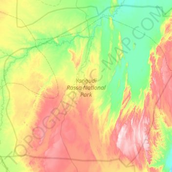
Name: Topografische Karte Yangudi Rassa National Park, Höhe, Relief.
Ort: Yangudi Rassa National Park, Afar Region, Ethiopia (10.67877 40.45691 11.23814 41.06262)
Durchschnittliche Höhe: 622 m
Minimale Höhe: 408 m
Maximale Höhe: 967 m
Its 4,731 square kilometres (1,827 sq mi) of territory include Mount Yangudi (1,383 m or 4,537 ft) near the southern boundary and the surrounding Rassa Plains, with altitudes from 400 to 1,459 m (1,312 to 4,787 ft) above sea level. The Awash River flows through the park from south to north.
Andere topografische Karten
Klicken Sie auf eine Karte, um ihre Topografie, ihre Höhe und ihr Relief anzuzeigen.
Dalol Bota
Dalol Bota, Zone 2, Afar Region, Ethiopia
Durchschnittliche Höhe: 57 m
Danakil Depression
Danakil Depression, Zone 2, Afar Region, Ethiopia
Durchschnittliche Höhe: -105 m
Asaita
Ethiopia > Afar Region > Asaita
Asaita, Zone 1, Afar Region, Ethiopia
Durchschnittliche Höhe: 366 m
Name Not Known
Name Not Known, Zone 1, Afar Region, Ethiopia
Durchschnittliche Höhe: 83 m