
Topografische Karte Saint-Louis-de-Blandford
Interaktive Karte
Klicken Sie auf die Karte, um die Höhe anzuzeigen.
Über diese Karte
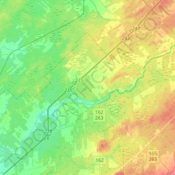
Name: Topografische Karte Saint-Louis-de-Blandford, Höhe, Relief.
Durchschnittliche Höhe: 104 m
Minimale Höhe: 81 m
Maximale Höhe: 141 m
Andere topografische Karten
Klicken Sie auf eine Karte, um ihre Topografie, ihre Höhe und ihr Relief anzuzeigen.
Warwick
Canada > Quebec > Arthabaska
Warwick, Arthabaska, Centre-du-Québec, Quebec, J0A 1M0, Canada
Durchschnittliche Höhe: 165 m
Daveluyville
Canada > Quebec > Arthabaska
Daveluyville, Arthabaska, Centre-du-Québec, Quebec, G0Z 1C0, Canada
Durchschnittliche Höhe: 93 m
Saint-Norbert-d'Arthabaska
Canada > Quebec > Arthabaska
Saint-Norbert-d'Arthabaska, Arthabaska, Centre-du-Québec, Quebec, Canada
Durchschnittliche Höhe: 237 m
Sainte-Clotilde-de-Horton
Canada > Quebec > Arthabaska
Sainte-Clotilde-de-Horton, Arthabaska, Centre-du-Québec, Quebec, J0A 1H0, Canada
Durchschnittliche Höhe: 97 m
Notre-Dame-de-Ham
Canada > Quebec > Arthabaska > Notre-Dame-de-Ham
Notre-Dame-de-Ham, Arthabaska, Centre-du-Québec, Quebec, G0P 1C0, Canada
Durchschnittliche Höhe: 323 m
Île Perrot
Canada > Quebec > Arthabaska > Victoriaville
Île Perrot, Victoriaville, Arthabaska, Centre-du-Québec, Quebec, G6P 1T9, Canada
Durchschnittliche Höhe: 180 m
Kingsey Falls
Canada > Quebec > Arthabaska
Kingsey Falls, Arthabaska, Centre-du-Québec, Quebec, J0A 1B0, Canada
Durchschnittliche Höhe: 138 m
Saint-Albert
Canada > Quebec > Arthabaska
Saint-Albert, Arthabaska, Centre-du-Québec, Quebec, J0A 1E0, Canada
Durchschnittliche Höhe: 118 m
Victoriaville
Canada > Quebec > Arthabaska
Victoriaville, Arthabaska, Centre-du-Québec, Quebec, Canada
Durchschnittliche Höhe: 146 m
Chesterville
Canada > Quebec > Arthabaska
Chesterville, Arthabaska, Centre-du-Québec, Quebec, G0P 1J0, Canada
Durchschnittliche Höhe: 288 m
Trottier Mills
Canada > Quebec > Arthabaska > Sainte-Hélène-de-Chester
Trottier Mills, Sainte-Hélène-de-Chester, Arthabaska, Centre-du-Québec, Quebec, Canada
Durchschnittliche Höhe: 332 m