
Spenden
Rüsten Sie sich für Ihr nächstes Abenteuer:
Als Amazon-Partner verdient diese Website an qualifizierten Käufen, ohne dass Ihnen zusätzliche Kosten entstehen.
Topografische Karte Sanders
Klicken Sie auf die Karte, um die Höhe anzuzeigen.
Spenden
Rüsten Sie sich für Ihr nächstes Abenteuer:
Als Amazon-Partner verdient diese Website an qualifizierten Käufen, ohne dass Ihnen zusätzliche Kosten entstehen.
Über diese Karte
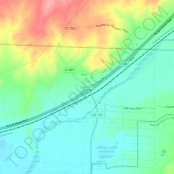
Name: Topografische Karte Sanders, Höhe, Relief.
Ort: Sanders, Apache County, Arizona, 86512, United States (35.19641 -109.35371 35.23641 -109.31371)
Durchschnittliche Höhe: 1.801 m
Minimale Höhe: 1.765 m
Maximale Höhe: 1.872 m
Spenden
Rüsten Sie sich für Ihr nächstes Abenteuer:
Als Amazon-Partner verdient diese Website an qualifizierten Käufen, ohne dass Ihnen zusätzliche Kosten entstehen.
Andere topografische Karten
Klicken Sie auf eine Karte, um ihre Topografie, ihre Höhe und ihr Relief anzuzeigen.
Petrified Forest National Park
United States > Arizona > Apache County
Averaging about 5,400 feet (1,600 m) in elevation, the park has a dry windy climate with temperatures that vary from summer highs of about 100 °F (38 °C) to winter lows well below freezing. More than 400 species of plants, dominated by grasses such as bunchgrass, blue grama, and sacaton, are found in the…
Durchschnittliche Höhe: 1.722 m
Alpine
United States > Arizona > Apache County > Alpine
Located approximately 75 miles south of the Navajo Nation, Alpine was settled in 1876 by Anderson Bush, a European-American who built a log house there. He originally used it as a trading post known as "Fort Bush". Bush sold his holdings in 1879 to William Maxwell and Fred Hamblin, Mormon settlers who…
Durchschnittliche Höhe: 2.465 m
Window Rock
United States > Arizona > Apache County
Window Rock is categorized as being within the 6a USDA hardiness zone, meaning the average annual extreme minimum temperature is between −10 and −5 °F (−23 and −21 °C). The city is cooler than most of Arizona due to its high elevation.
Durchschnittliche Höhe: 2.084 m
Spenden
Rüsten Sie sich für Ihr nächstes Abenteuer:
Als Amazon-Partner verdient diese Website an qualifizierten Käufen, ohne dass Ihnen zusätzliche Kosten entstehen.
McNary
United States > Arizona > Apache County
At an elevation of 7,316 feet (2,230 m), it is the second highest community in Arizona after Alpine.
Durchschnittliche Höhe: 2.240 m
Petrified Forest National Park
United States > Arizona > Apache County
Averaging about 5,400 feet (1,600 m) in elevation, the park has a dry windy climate with temperatures that vary from summer highs of about 100 °F (38 °C) to winter lows well below freezing. More than 400 species of plants, dominated by grasses such as bunchgrass, blue grama, and sacaton, are found in the…
Durchschnittliche Höhe: 1.722 m
Spenden
Rüsten Sie sich für Ihr nächstes Abenteuer:
Als Amazon-Partner verdient diese Website an qualifizierten Käufen, ohne dass Ihnen zusätzliche Kosten entstehen.
Springerville
United States > Arizona > Apache County
Springerville sits at an elevation of 6,907 feet (2,105 m) above sea level. Along with its neighbor Eagar, the communities make up the place known as Round Valley, which is in the central-eastern part of Arizona close to the New Mexico border.
Durchschnittliche Höhe: 2.150 m
Spenden
Rüsten Sie sich für Ihr nächstes Abenteuer:
Als Amazon-Partner verdient diese Website an qualifizierten Käufen, ohne dass Ihnen zusätzliche Kosten entstehen.
Petrified Forest National Park
United States > Arizona > Apache County
Averaging about 5,400 feet (1,600 m) in elevation, the park has a dry windy climate with temperatures that vary from summer highs of about 100 °F (38 °C) to winter lows well below freezing. More than 400 species of plants, dominated by grasses such as bunchgrass, blue grama, and sacaton, are found in the…
Durchschnittliche Höhe: 1.722 m
Canyon de Chelly National Monument
United States > Arizona > Apache County
Durchschnittliche Höhe: 1.938 m
Spenden
Rüsten Sie sich für Ihr nächstes Abenteuer:
Als Amazon-Partner verdient diese Website an qualifizierten Käufen, ohne dass Ihnen zusätzliche Kosten entstehen.