
Topografische Karte Rhinecliff
Interaktive Karte
Klicken Sie auf die Karte, um die Höhe anzuzeigen.
Über diese Karte
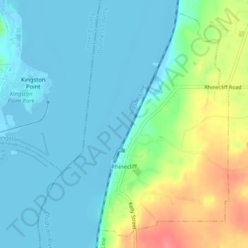
Name: Topografische Karte Rhinecliff, Höhe, Relief.
Durchschnittliche Höhe: 19 m
Minimale Höhe: -9 m
Maximale Höhe: 73 m
The hamlet is demarcated by large agricultural and wooded area to the north, east, and south, and bounded by the Hudson River on the west. Steep topography, formed by contorted slate ridges and valleys, define the site-specific and seemingly random orientation of the small, frame nineteenth-century houses and winding narrow roads. The hamlet had a mid-nineteenth century building boom, but its boundaries and building density have changed very little over the last one hundred years.
Andere topografische Karten
Klicken Sie auf eine Karte, um ihre Topografie, ihre Höhe und ihr Relief anzuzeigen.
Drayton Grant Park at Burger Hill
United States > New York > Dutchess County > Town of Rhinebeck
Drayton Grant Park at Burger Hill, Town of Rhinebeck, Dutchess County, New York, United States
Durchschnittliche Höhe: 102 m