
Topografische Karte Chattogram
Interaktive Karte
Klicken Sie auf die Karte, um die Höhe anzuzeigen.
Über diese Karte
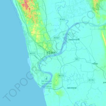
Name: Topografische Karte Chattogram, Höhe, Relief.
Durchschnittliche Höhe: 6 m
Minimale Höhe: -2 m
Maximale Höhe: 102 m
Chittagong lies at 22°22′0″N 91°48′0″E / 22.36667°N 91.80000°E / 22.36667; 91.80000. It straddles the coastal foothills of the Chittagong Hill Tracts in southeastern Bangladesh. The Karnaphuli River runs along the southern banks of the city, including its central business district. The river enters the Bay of Bengal in an estuary located 12 kilometres (7.5 mi) west of downtown Chittagong. Mount Sitakunda is the highest peak in Chittagong District, with an elevation of 351 metres (1,152 ft). Within the city itself, the highest peak is Batali Hill at 85.3 metres (280 ft). Chittagong has many lakes that were created under Mughal rule. In 1924, an engineering team of the Assam Bengal Railway established the Foy's Lake.
Andere topografische Karten
Klicken Sie auf eine Karte, um ihre Topografie, ihre Höhe und ihr Relief anzuzeigen.
Chaktai khal
Bangladesh > Chattogram Division > Chattogram
Chaktai khal, Chattogram, Chattogram District, Chattogram Division, 4000, Bangladesh
Durchschnittliche Höhe: 11 m
Chattogram
Bangladesh > Chattogram Division > Chattogram
Chattogram, Chattogram District, Chattogram Division, 4000, Bangladesh
Durchschnittliche Höhe: 6 m