
Topografische Karte Otero County
Interaktive Karte
Klicken Sie auf die Karte, um die Höhe anzuzeigen.
Über diese Karte
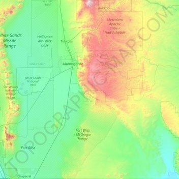
Name: Topografische Karte Otero County, Höhe, Relief.
Ort: Otero County, Novo México, Estados Unidos da América (32.00012 -106.37743 33.39069 -104.84766)
Durchschnittliche Höhe: 1.595 m
Minimale Höhe: 1.101 m
Maximale Höhe: 3.542 m
Andere topografische Karten
Klicken Sie auf eine Karte, um ihre Topografie, ihre Höhe und ihr Relief anzuzeigen.
Alamogordo
Estados Unidos da América > Novo México > Otero County
Alamogordo, Otero County, Novo México, 88310, Estados Unidos da América
Durchschnittliche Höhe: 1.644 m