
Topografische Karte Bright
Interaktive Karte
Klicken Sie auf die Karte, um die Höhe anzuzeigen.
Über diese Karte
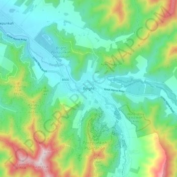
Name: Topografische Karte Bright, Höhe, Relief.
Ort: Bright, Alpine Shire, Victoria, 3741, Australia (-36.76853 146.92077 -36.68853 147.00077)
Durchschnittliche Höhe: 480 m
Minimale Höhe: 276 m
Maximale Höhe: 1.007 m
Owing to its elevation, Bright has a subtropical highland climate (Cfb) under the Köppen climate classification scheme, with four distinct seasons. Summer is warm and usually dry, with mild to cool nights. Autumn is mild and dry. Winters and spring are damp. Snowfall and frost are common during the winter months. The highest recorded temperature in Bright was 40.7 °C (105 °F) on 8 February 1983 and the lowest recorded temperature was −7.8 °C (18 °F) on 30 June 1986.