
Topografische Karte Blackwell Peninsula
Interaktive Karte
Klicken Sie auf die Karte, um die Höhe anzuzeigen.
Über diese Karte
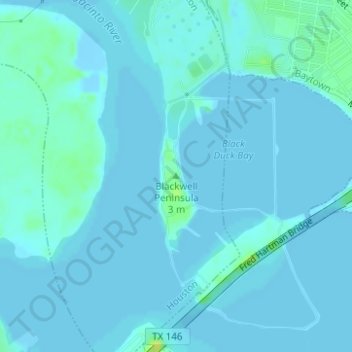
Name: Topografische Karte Blackwell Peninsula, Höhe, Relief.
Durchschnittliche Höhe: 2 m
Minimale Höhe: -8 m
Maximale Höhe: 20 m
Andere topografische Karten
Klicken Sie auf eine Karte, um ihre Topografie, ihre Höhe und ihr Relief anzuzeigen.
Tuffly Park
United States > Texas > Harris County > Houston
Tuffly Park, 3200, Greater Fifth Ward, Houston, Harris County, Texas, 77026, United States
Durchschnittliche Höhe: 16 m
Kings Point
United States > Texas > Harris County > Houston
Kings Point, Houston, Harris County, Texas, 77345, United States
Durchschnittliche Höhe: 20 m
Forest Cove
United States > Texas > Harris County > Houston
Forest Cove, Houston, Harris County, Texas, 77339, United States
Durchschnittliche Höhe: 24 m
East Houston
United States > Texas > Harris County > Houston > East Houston
East Houston, Houston, Harris County, Texas, 77028, United States
Durchschnittliche Höhe: 15 m
Harrisburg
United States > Texas > Harris County > Houston > Harrisburg
Harrisburg, Houston, Harris County, Texas, 77012, United States
Durchschnittliche Höhe: 10 m
Alief
United States > Texas > Harris County > Houston
Alief, Houston, Harris County, Texas, 77099, United States
Durchschnittliche Höhe: 25 m
Addicks
United States > Texas > Harris County > Houston > Addicks
Addicks, Houston, Harris County, Texas, 77077, United States
Durchschnittliche Höhe: 28 m