
Topografische Karte Saissac
Interaktive Karte
Klicken Sie auf die Karte, um die Höhe anzuzeigen.
Über diese Karte
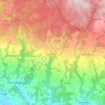
Name: Topografische Karte Saissac, Höhe, Relief.
Durchschnittliche Höhe: 473 m
Minimale Höhe: 151 m
Maximale Höhe: 852 m
The village is perched in the foothills of the Montagne Noire (Black Mountain) at an altitude of 467 m and has views of the Vernassonne Gorge as well as the valley plain which stretches between Carcassonne and Castelnaudary.
Andere topografische Karten
Klicken Sie auf eine Karte, um ihre Topografie, ihre Höhe und ihr Relief anzuzeigen.
Belcastel-et-Buc
Belcastel-et-Buc, Limoux, Aude, Occitania, Metropolitan France, 11580, France
Durchschnittliche Höhe: 535 m
Fa
France > Occitania > Aude > Val-du-Faby
Fa, Val-du-Faby, Limoux, Aude, Occitania, Metropolitan France, 11260, France
Durchschnittliche Höhe: 385 m
Sougraigne
Sougraigne, Limoux, Aude, Occitania, Metropolitan France, 11190, France
Durchschnittliche Höhe: 565 m
Saint-Michel-de-Lanès
Saint-Michel-de-Lanès, Carcassonne, Aude, Occitania, Metropolitan France, 11410, France
Durchschnittliche Höhe: 239 m
Carcassonne
Carcassonne, Aude, Occitania, Metropolitan France, 11000, France
Durchschnittliche Höhe: 149 m
Clermont-sur-Lauquet
Clermont-sur-Lauquet, Limoux, Aude, Occitania, Metropolitan France, 11250, France
Durchschnittliche Höhe: 502 m
Salles-d'Aude
Salles-d'Aude, Narbonne, Aude, Occitania, Metropolitan France, 11110, France
Durchschnittliche Höhe: 29 m
Fontjoncouse
Fontjoncouse, Narbonne, Aude, Occitania, Metropolitan France, 11360, France
Durchschnittliche Höhe: 250 m
Pradelles-Cabardès
Pradelles-Cabardès, Carcassonne, Aude, Occitania, Metropolitan France, 11380, France
Durchschnittliche Höhe: 836 m
Fontiers-Cabardès
Fontiers-Cabardès, Carcassonne, Aude, Occitania, Metropolitan France, 11390, France
Durchschnittliche Höhe: 619 m
Castelnaudary
Castelnaudary, Carcassonne, Aude, Occitania, Metropolitan France, 11400, France
Durchschnittliche Höhe: 174 m