
Topografische Karte Metzeresche
Klicken Sie auf die Karte, um die Höhe anzuzeigen.
Über diese Karte
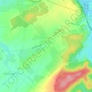
Name: Topografische Karte Metzeresche, Höhe, Relief.
Durchschnittliche Höhe: 227 m
Minimale Höhe: 179 m
Maximale Höhe: 300 m
Andere topografische Karten
Klicken Sie auf eine Karte, um ihre Topografie, ihre Höhe und ihr Relief anzuzeigen.
Réserve biologique dirigée des Vallons de Gorze
France > Grand Est > Moselle > Gorze > Saint-Thiébaut
Durchschnittliche Höhe: 272 m
Ouvrage des Carrières d'Amanvillers
France > Grand Est > Moselle > Norroy-le-Veneur
Durchschnittliche Höhe: 331 m
Hartzviller
France > Grand Est > Moselle > Hartzviller > Hartzviller
Elle est située à une altitude comprise entre 275 et 376 m. La municipalité est une relativement petite commune de 4,14 km², la superficie moyenne des communes de Moselle étant de 8,6 km².
Durchschnittliche Höhe: 321 m
Étang de la Grande Creusière
France > Grand Est > Moselle > Diane-Capelle
Durchschnittliche Höhe: 275 m
Cité Émile Huchet
France > Grand Est > Moselle > Saint-Avold > Cité Émile Huchet
Durchschnittliche Höhe: 253 m