
Topografische Karte Durgam Cheruvu
Interaktive Karte
Klicken Sie auf die Karte, um die Höhe anzuzeigen.
Über diese Karte
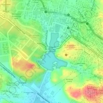
Name: Topografische Karte Durgam Cheruvu, Höhe, Relief.
Durchschnittliche Höhe: 577 m
Minimale Höhe: 540 m
Maximale Höhe: 629 m
Andere topografische Karten
Klicken Sie auf eine Karte, um ihre Topografie, ihre Höhe und ihr Relief anzuzeigen.
Ward 104 Kondapur
Ward 104 Kondapur, Greater Hyderabad Municipal Corporation West Zone, Hyderabad, Rangareddy, Telangana, India
Durchschnittliche Höhe: 582 m
Amber cheruvu
Amber cheruvu, Eswar Villas road, Sreenivasa Nagar, Ward 123 Hydernagar, Greater Hyderabad Municipal Corporation West Zone, Hyderabad, Kukatpally mandal, Medchal–Malkajgiri, Telangana, 500085, India
Durchschnittliche Höhe: 590 m
Greater Hyderabad Municipal Corporation Central Zone
Greater Hyderabad Municipal Corporation Central Zone, Hyderabad, Khairatabad mandal, Hyderabad, Telangana, India
Durchschnittliche Höhe: 533 m
Greater Hyderabad Municipal Corporation South Zone
Greater Hyderabad Municipal Corporation South Zone, Hyderabad, Bahadurpura mandal, Hyderabad, Telangana, India
Durchschnittliche Höhe: 535 m
Kappala Cheruvu
Kappala Cheruvu, SH19, sripuram, Ward 14 BN Reddy Nagar, Greater Hyderabad Municipal Corporation East Zone, Hyderabad, Hayathnagar mandal, Rangareddy, Telangana, 500070, India
Durchschnittliche Höhe: 537 m
Ward 135 Venkatapuram
Ward 135 Venkatapuram, Greater Hyderabad Municipal Corporation North Zone, Hyderabad, Medchal–Malkajgiri, Telangana, India
Durchschnittliche Höhe: 556 m
JawaharNagar Colony Park
JawaharNagar Colony Park, Jawahar Nagar Colony, Ward 148 Ramgopalpet, Greater Hyderabad Municipal Corporation North Zone, Hyderabad, Secunderabad mandal, Hyderabad, Telangana, India
Durchschnittliche Höhe: 524 m