

Topografische Karte Merang
Klicken Sie auf die Karte, um die Höhe anzuzeigen.
Über diese Karte
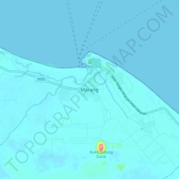
Name: Topografische Karte Merang, Höhe, Relief.
Ort: Merang, Setiu, Terengganu, Malaysia (5.48309 102.90693 5.56309 102.98693)
Durchschnittliche Höhe: 6 m
Minimale Höhe: -1 m
Maximale Höhe: 156 m
Andere topografische Karten
Klicken Sie auf eine Karte, um ihre Topografie, ihre Höhe und ihr Relief anzuzeigen.

Marang
Marang has an area of 666 km2. The district's topography consists of the South China Sea coast, peat swamps, hills and plains. The sub-districts (Malay: mukim) of Rusila, Pulau Kerengga and Merchang lie on the coast with sandy plains gradually giving way to hills in the interior. The Jerong sub-district is…
Durchschnittliche Höhe: 30 m






Marang
Marang has an area of 666 km². The district's topography consists of the South China Sea coast, peat swamps, hills and plains. The sub-districts (Malay: mukim) of Rusila, Pulau Kerengga and Merchang lie on the coast with sandy plains gradually giving way to hills in the interior. The Jerong sub-district is…
Durchschnittliche Höhe: 30 m




Batu Buruk Beach
Malaysia > Terengganu > Kuala Terengganu > Kuala Terengganu
Durchschnittliche Höhe: 4 m


Marang
Marang has an area of 666 km2. The district's topography consists of the South China Sea coast, peat swamps, hills and plains. The sub-districts (Malay: mukim) of Rusila, Pulau Kerengga and Merchang lie on the coast with sandy plains gradually giving way to hills in the interior. The Jerong sub-district is…
Durchschnittliche Höhe: 30 m

Duyung Small Island
Malaysia > Terengganu > Kuala Terengganu > Kuala Terengganu
Durchschnittliche Höhe: 4 m



Batu Burok Public Park
Malaysia > Terengganu > Kuala Terengganu > Kuala Terengganu
Durchschnittliche Höhe: 5 m
Sekati Island
Malaysia > Terengganu > Kuala Terengganu > Kampung Pulau Sekati
Durchschnittliche Höhe: 6 m
Duyong Island
Malaysia > Terengganu > Kuala Terengganu > Kampung Duyong Wan Su
Durchschnittliche Höhe: 4 m
Pak Mat Lebai Island
Malaysia > Terengganu > Kuala Terengganu > Kuala Terengganu
Durchschnittliche Höhe: 6 m

Taman Tamadun Islam (Mini Islam)
Malaysia > Terengganu > Kuala Terengganu > Kuala Terengganu
Durchschnittliche Höhe: 5 m

Stadium Mini Mak Chili
Malaysia > Terengganu > Kemaman District > Kampung Kaya
Durchschnittliche Höhe: 7 m


Sungai Kandang Rusa
Malaysia > Terengganu > Kemaman District > Kampung Semayor
Durchschnittliche Höhe: 32 m

Sungai Kerteh
Malaysia > Terengganu > Kemaman District > Kampung Batu Putih
Durchschnittliche Höhe: 30 m
