
Topografische Karte Burke Center
Interaktive Karte
Klicken Sie auf die Karte, um die Höhe anzuzeigen.
Über diese Karte
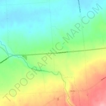
Name: Topografische Karte Burke Center, Höhe, Relief.
Durchschnittliche Höhe: 217 m
Minimale Höhe: 170 m
Maximale Höhe: 292 m
Andere topografische Karten
Klicken Sie auf eine Karte, um ihre Topografie, ihre Höhe und ihr Relief anzuzeigen.
Town of Westville
United States > New York > Franklin County
Town of Westville, Franklin County, New York, United States
Durchschnittliche Höhe: 79 m
Town of Moira
United States > New York > Franklin County
Town of Moira, Franklin County, New York, United States
Durchschnittliche Höhe: 125 m
Village of Tupper Lake
United States > New York > Franklin County
Village of Tupper Lake, Town of Tupper Lake, Franklin County, New York, 12986, United States
Durchschnittliche Höhe: 484 m
Hogansburg
United States > New York > Franklin County > Town of Bombay
Hogansburg, Town of Bombay, Franklin County, New York, 13655, United States
Durchschnittliche Höhe: 55 m
Fish Creek Pond Campground
United States > New York > Franklin County > Town of Santa Clara
Fish Creek Pond Campground, Town of Santa Clara, Franklin County, New York, United States
Durchschnittliche Höhe: 488 m
Town of Chateaugay
United States > New York > Franklin County > Town of Chateaugay
Town of Chateaugay, Franklin County, New York, 12920, United States
Durchschnittliche Höhe: 280 m
Owls Head
United States > New York > Franklin County
Owls Head, Town of Bellmont, Franklin County, New York, 12969, United States
Durchschnittliche Höhe: 554 m
Paul Smiths
United States > New York > Franklin County > Paul Smiths
Paul Smiths, Brighton, Franklin County, New York, 12970, United States
Durchschnittliche Höhe: 508 m
Moira
United States > New York > Franklin County > Moira
Moira, Franklin County, New York, 12957, United States
Durchschnittliche Höhe: 125 m