
Topografische Karte Forest
Interaktive Karte
Klicken Sie auf die Karte, um die Höhe anzuzeigen.
Über diese Karte
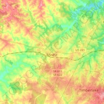
Name: Topografische Karte Forest, Höhe, Relief.
Ort: Forest, Bedford County, Virginia, 24551, United States (37.31706 -79.34234 37.41619 -79.23274)
Durchschnittliche Höhe: 257 m
Minimale Höhe: 196 m
Maximale Höhe: 319 m
Andere topografische Karten
Klicken Sie auf eine Karte, um ihre Topografie, ihre Höhe und ihr Relief anzuzeigen.
Hardy
United States > Virginia > Bedford County
Hardy, Bedford County, Virginia, United States
Durchschnittliche Höhe: 289 m
Elk Creek
United States > Virginia > Bedford County
Elk Creek, Bedford County, Virginia, United States
Durchschnittliche Höhe: 218 m
Huddleston
United States > Virginia > Bedford County
Huddleston, Bedford County, Virginia, United States
Durchschnittliche Höhe: 226 m
Norwood
United States > Virginia > Bedford County > Norwood
Norwood, Bedford County, Virginia, 24556, United States
Durchschnittliche Höhe: 276 m