
Spenden
Rüsten Sie sich für Ihr nächstes Abenteuer:
Als Amazon-Partner verdient diese Website an qualifizierten Käufen, ohne dass Ihnen zusätzliche Kosten entstehen.
Topografische Karte Penang Hill
Klicken Sie auf die Karte, um die Höhe anzuzeigen.
Spenden
Rüsten Sie sich für Ihr nächstes Abenteuer:
Als Amazon-Partner verdient diese Website an qualifizierten Käufen, ohne dass Ihnen zusätzliche Kosten entstehen.
Penang Hill
A number of hills are covered by Penang Hill, with the highest point being Western Hill that stands at an altitude of 833 meters (2,733 feet) above sea level. Penang Hill is a hilly and forested area that stands out from the lowlands of Malaysia by being hilly and wooded. The area was used as a retreat during the British colonial period, and is now a very popular tourist destination due to its history and heritage.
Spenden
Rüsten Sie sich für Ihr nächstes Abenteuer:
Als Amazon-Partner verdient diese Website an qualifizierten Käufen, ohne dass Ihnen zusätzliche Kosten entstehen.
Über diese Karte
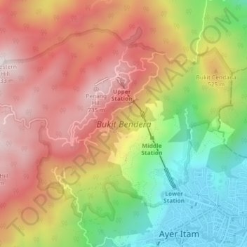
Name: Topografische Karte Penang Hill, Höhe, Relief.
Durchschnittliche Höhe: 436 m
Minimale Höhe: 16 m
Maximale Höhe: 804 m
Spenden
Rüsten Sie sich für Ihr nächstes Abenteuer:
Als Amazon-Partner verdient diese Website an qualifizierten Käufen, ohne dass Ihnen zusätzliche Kosten entstehen.