
Topografische Karte Hameau Gosselin
Interaktive Karte
Klicken Sie auf die Karte, um die Höhe anzuzeigen.
Über diese Karte
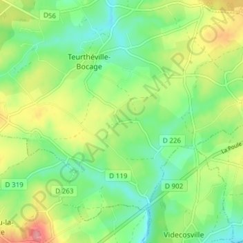
Name: Topografische Karte Hameau Gosselin, Höhe, Relief.
Durchschnittliche Höhe: 76 m
Minimale Höhe: 41 m
Maximale Höhe: 133 m
Andere topografische Karten
Klicken Sie auf eine Karte, um ihre Topografie, ihre Höhe und ihr Relief anzuzeigen.
Sainte-Croix
France > Normandie > Manche > Teurthéville-Bocage
Sainte-Croix, Teurthéville-Bocage, Cherbourg, Manche, Normandie, France métropolitaine, 50630, France
Durchschnittliche Höhe: 83 m
Le Moulin de Coisel
France > Normandie > Manche > Teurthéville-Bocage
Le Moulin de Coisel, Teurthéville-Bocage, Cherbourg, Manche, Normandie, France métropolitaine, 50630, France
Durchschnittliche Höhe: 73 m
Hameau Cadel
France > Normandie > Manche > Teurthéville-Bocage
Hameau Cadel, Teurthéville-Bocage, Cherbourg, Manche, Normandie, France métropolitaine, 50630, France
Durchschnittliche Höhe: 74 m