
Topografische Karte Kluane National Park and Reserve
Interaktive Karte
Klicken Sie auf die Karte, um die Höhe anzuzeigen.
Über diese Karte
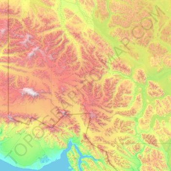
Name: Topografische Karte Kluane National Park and Reserve, Höhe, Relief.
Ort: Kluane National Park and Reserve, Yukon, Canada (59.99964 -141.00198 61.33741 -137.01009)
Durchschnittliche Höhe: 1.536 m
Minimale Höhe: -1 m
Maximale Höhe: 5.871 m
The Reserve includes the highest mountain in Canada, Mount Logan (5,959 metres or 19,551 feet) of the Saint Elias Mountains. Mountains and glaciers dominate the park's landscape, covering 83% of its area. The rest of the land in the park is forest and tundra—east of the largest mountains and glaciers—where the climate is colder and drier than in the western and southern parts of the park. Trees grow only at the park's lowest elevations. The primary tree species are white spruce, balsam poplar and trembling aspen.
Andere topografische Karten
Klicken Sie auf eine Karte, um ihre Topografie, ihre Höhe und ihr Relief anzuzeigen.
Herschel Island
Herschel Island, Inuvialuit Settlement Region, Yukon, Canada
Durchschnittliche Höhe: 22 m
Dawson City
Canada > Yukon > Dawson City
Dawson City, Town of Dawson City, Yukon, Unorganized, Yukon, Canada
Durchschnittliche Höhe: 510 m
Tombstone Territorial Park
Tombstone Territorial Park, Yukon, Canada
Durchschnittliche Höhe: 1.546 m
Kusawa Lake;Takhini River
Kusawa Lake;Takhini River, Yukon, Canada
Durchschnittliche Höhe: 705 m
Lake Laberge
Lake Laberge, Macpherson-Grizzly Valley, Yukon, Canada
Durchschnittliche Höhe: 710 m
Teslin River
Teslin River, Yukon, Unorganized, Yukon, Canada
Durchschnittliche Höhe: 1.112 m
Burwash Landing
Canada > Yukon > Burwash Landing
Burwash Landing, Yukon, Y1A 3V4, Canada
Durchschnittliche Höhe: 828 m
Ogilvie River
Ogilvie River, Yukon, Unorganized, Yukon, Canada
Durchschnittliche Höhe: 451 m
Teslin Lake
Canada > Yukon > Teslin Post 13
Teslin Lake, Teslin Post 13, Yukon, Canada
Durchschnittliche Höhe: 1.084 m
Two Mile Village
Canada > Yukon > Watson Lake
Two Mile Village, Watson Lake, Yukon, Y0A 1C0, Canada
Durchschnittliche Höhe: 703 m
Ivvavik National Park
Ivvavik National Park, Yukon, Canada
Durchschnittliche Höhe: 427 m
Little Salmon Lake
Little Salmon Lake, Yukon, Unorganized, Yukon, Canada
Durchschnittliche Höhe: 694 m
Kluane Lake
Canada > Yukon > Burwash Landing
Kluane Lake, Sedata Street, Burwash Landing, Yukon, Unorganized, Yukon, Y1A 3V4, Canada
Durchschnittliche Höhe: 1.381 m
Destruction Bay
Canada > Yukon > Destruction Bay
Destruction Bay, Yukon, Y0B 1H0, Canada
Durchschnittliche Höhe: 893 m
Big Salmon River
Big Salmon River, Yukon, Unorganized, Yukon, Canada
Durchschnittliche Höhe: 1.197 m
Morley River
Morley River, Yukon, Unorganized, Yukon, Canada
Durchschnittliche Höhe: 837 m