
Spenden
Rüsten Sie sich für Ihr nächstes Abenteuer:
Als Amazon-Partner verdient diese Website an qualifizierten Käufen, ohne dass Ihnen zusätzliche Kosten entstehen.
Topografische Karte Hulu Kelang
Klicken Sie auf die Karte, um die Höhe anzuzeigen.
Spenden
Rüsten Sie sich für Ihr nächstes Abenteuer:
Als Amazon-Partner verdient diese Website an qualifizierten Käufen, ohne dass Ihnen zusätzliche Kosten entstehen.
Hulu Kelang
It has an area of 16.94 square kilometres, and is located northeast of Kuala Lumpur. The surface is relatively high; 500 metres above sea level, and the topography here is highland, lowland, or undulating land. As a result, it is a rain catchment area for the Klang River. Among the high locations are Bukit Antarabangsa, Bukit Kemensah, and Bukit Belacan. The hill is composed of limestone, which is brittle and dissolves during heavy rains. As a result, several landslides have occurred in this area, forcing people mainly living in flats, as well as some houses on the hillside, to evacuate. A notable incident is the collapse of Highland Towers in 1993. Moreover, the flow of the Klang River was straightened in several places, which caused water to flow faster, leading Kuala Lumpur to experience flash floods on June 10, 2007.
Spenden
Rüsten Sie sich für Ihr nächstes Abenteuer:
Als Amazon-Partner verdient diese Website an qualifizierten Käufen, ohne dass Ihnen zusätzliche Kosten entstehen.
Über diese Karte
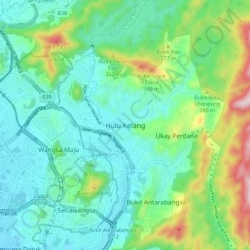
Name: Topografische Karte Hulu Kelang, Höhe, Relief.
Durchschnittliche Höhe: 147 m
Minimale Höhe: 40 m
Maximale Höhe: 469 m
Spenden
Rüsten Sie sich für Ihr nächstes Abenteuer:
Als Amazon-Partner verdient diese Website an qualifizierten Käufen, ohne dass Ihnen zusätzliche Kosten entstehen.
Andere topografische Karten
Klicken Sie auf eine Karte, um ihre Topografie, ihre Höhe und ihr Relief anzuzeigen.
Kampung Ampang Indah
Malaysia > Selangor > Ampang Jaya Municipal Council
Durchschnittliche Höhe: 131 m
Spenden
Rüsten Sie sich für Ihr nächstes Abenteuer:
Als Amazon-Partner verdient diese Website an qualifizierten Käufen, ohne dass Ihnen zusätzliche Kosten entstehen.
Ampang River
Malaysia > Selangor > Ampang Jaya Municipal Council > Kampung Muhibbah
Durchschnittliche Höhe: 71 m
Spenden
Rüsten Sie sich für Ihr nächstes Abenteuer:
Als Amazon-Partner verdient diese Website an qualifizierten Käufen, ohne dass Ihnen zusätzliche Kosten entstehen.
Kawasan Rekreasi AU2 Keramat
Malaysia > Selangor > Ampang Jaya Municipal Council
Durchschnittliche Höhe: 74 m