
Topografische Karte Fredonia
Interaktive Karte
Klicken Sie auf die Karte, um die Höhe anzuzeigen.
Über diese Karte
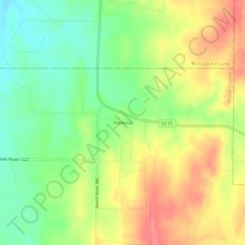
Name: Topografische Karte Fredonia, Höhe, Relief.
Ort: Fredonia, Mason County, Texas, 76842, United States (30.91212 -99.13338 30.95212 -99.09338)
Durchschnittliche Höhe: 509 m
Minimale Höhe: 474 m
Maximale Höhe: 545 m
Andere topografische Karten
Klicken Sie auf eine Karte, um ihre Topografie, ihre Höhe und ihr Relief anzuzeigen.
Grit
United States > Texas > Mason County
Grit, Mason County, Texas, United States
Durchschnittliche Höhe: 529 m
Art
United States > Texas > Mason County
Art, Mason County, Texas, United States
Durchschnittliche Höhe: 426 m
Pontotoc
United States > Texas > Mason County
Pontotoc, Mason County, Texas, 76869, United States
Durchschnittliche Höhe: 470 m
Mason
United States > Texas > Mason County
Mason, Mason County, Texas, 76856, United States
Durchschnittliche Höhe: 484 m
Streeter
United States > Texas > Mason County
Streeter, Mason County, Texas, United States
Durchschnittliche Höhe: 521 m