
Topografische Karte Bradley Creek Point
Interaktive Karte
Klicken Sie auf die Karte, um die Höhe anzuzeigen.
Über diese Karte
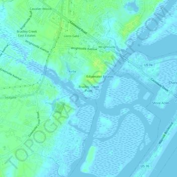
Name: Topografische Karte Bradley Creek Point, Höhe, Relief.
Durchschnittliche Höhe: 3 m
Minimale Höhe: -4 m
Maximale Höhe: 12 m
Andere topografische Karten
Klicken Sie auf eine Karte, um ihre Topografie, ihre Höhe und ihr Relief anzuzeigen.
Forest Hills
United States > North Carolina > New Hanover County > Wilmington
Forest Hills, Wilmington, New Hanover County, North Carolina, 28403, United States
Durchschnittliche Höhe: 11 m
Windemere
United States > North Carolina > New Hanover County > Wilmington
Windemere, Wilmington, New Hanover County, North Carolina, 28405, United States
Durchschnittliche Höhe: 10 m
Seagate
United States > North Carolina > New Hanover County > Wilmington
Seagate, Wilmington, New Hanover County, North Carolina, 28403, United States
Durchschnittliche Höhe: 5 m