
Topografische Karte Bubertré
Interaktive Karte
Klicken Sie auf die Karte, um die Höhe anzuzeigen.
Über diese Karte
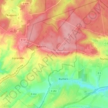
Name: Topografische Karte Bubertré, Höhe, Relief.
Durchschnittliche Höhe: 266 m
Minimale Höhe: 198 m
Maximale Höhe: 319 m
Andere topografische Karten
Klicken Sie auf eine Karte, um ihre Topografie, ihre Höhe und ihr Relief anzuzeigen.
Belle Perche
France > Normandie > Orne > Tourouvre au Perche
Belle Perche, Randonnai, Tourouvre au Perche, Mortagne-au-Perche, Orne, Normandie, France métropolitaine, 61190, France
Durchschnittliche Höhe: 266 m
L'Etre Châtel
France > Normandie > Orne > Tourouvre au Perche
L'Etre Châtel, Autheuil, Tourouvre au Perche, Mortagne-au-Perche, Orne, Normandie, France métropolitaine, 61190, France
Durchschnittliche Höhe: 225 m
Lignerolles
France > Normandie > Orne > Tourouvre au Perche
Lignerolles, Tourouvre au Perche, Mortagne-au-Perche, Orne, Normandie, France métropolitaine, 61190, France
Durchschnittliche Höhe: 275 m
Autheuil
France > Normandie > Orne > Tourouvre au Perche
Autheuil, Tourouvre au Perche, Mortagne-au-Perche, Orne, Normandie, France métropolitaine, 61190, France
Durchschnittliche Höhe: 222 m
La Sablonnière
France > Normandie > Orne > Tourouvre au Perche > La Sablonnière
La Sablonnière, Tourouvre, Tourouvre au Perche, Mortagne-au-Perche, Orne, Normandie, France métropolitaine, 61190, France
Durchschnittliche Höhe: 257 m
La Planche
France > Normandie > Orne > Tourouvre au Perche > La Planche
La Planche, Autheuil, Tourouvre au Perche, Mortagne-au-Perche, Orne, Normandie, France métropolitaine, 61190, France
Durchschnittliche Höhe: 226 m
Bresolettes
France > Normandie > Orne > Tourouvre au Perche
Bresolettes, Tourouvre au Perche, Mortagne-au-Perche, Orne, Normandie, France métropolitaine, 61190, France
Durchschnittliche Höhe: 281 m