
Topografische Karte Huamachuco
Interaktive Karte
Klicken Sie auf die Karte, um die Höhe anzuzeigen.
Über diese Karte
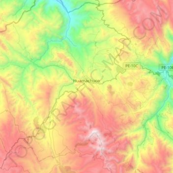
Name: Topografische Karte Huamachuco, Höhe, Relief.
Ort: Huamachuco, Province of Sánchez Carrión, La Libertad, Peru (-7.95735 -78.18765 -7.69427 -77.88111)
Durchschnittliche Höhe: 3.359 m
Minimale Höhe: 2.231 m
Maximale Höhe: 4.720 m
The hamlets at higher elevations (3900–4000 m.) were bases for their herding of domesticated animals, as agriculture could not survive at those heights. The settlements in the lower elevations (2500–3000 m.) contained large amounts of agricultural tools, showing the importance of crops.