
Topografische Karte Buncom
Interaktive Karte
Klicken Sie auf die Karte, um die Höhe anzuzeigen.
Über diese Karte
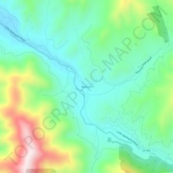
Name: Topografische Karte Buncom, Höhe, Relief.
Ort: Buncom, Jackson County, Oregon, United States (42.15401 -123.01810 42.19401 -122.97810)
Durchschnittliche Höhe: 654 m
Minimale Höhe: 471 m
Maximale Höhe: 1.089 m
Andere topografische Karten
Klicken Sie auf eine Karte, um ihre Topografie, ihre Höhe und ihr Relief anzuzeigen.
Medford
United States > Oregon > Jackson County
Medford, Jackson County, Oregon, United States
Durchschnittliche Höhe: 441 m
Lower Table Rock Trail
United States > Oregon > Jackson County
Lower Table Rock Trail, Jackson County, Oregon, United States
Durchschnittliche Höhe: 453 m
Gold Hill
United States > Oregon > Jackson County
Gold Hill, Jackson County, Oregon, United States
Durchschnittliche Höhe: 416 m
Rogue River
United States > Oregon > Jackson County
Rogue River, Jackson County, Oregon, 97537, United States
Durchschnittliche Höhe: 362 m
Siskiyou Gap
United States > Oregon > Jackson County
Siskiyou Gap, Jackson County, Oregon, United States
Durchschnittliche Höhe: 1.746 m
Jacksonville
United States > Oregon > Jackson County
Jacksonville, Jackson County, Oregon, 97530, United States
Durchschnittliche Höhe: 522 m
Ashland
United States > Oregon > Jackson County
Ashland, Jackson County, Oregon, United States
Durchschnittliche Höhe: 774 m
Lakecreek
United States > Oregon > Jackson County
Lakecreek, Jackson County, Oregon, United States
Durchschnittliche Höhe: 538 m