
Topografische Karte Bahir Dar Special Zone
Interaktive Karte
Klicken Sie auf die Karte, um die Höhe anzuzeigen.
Über diese Karte
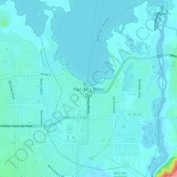
Name: Topografische Karte Bahir Dar Special Zone, Höhe, Relief.
Ort: Bahir Dar Special Zone, Amhara Region, Ethiopia (11.57123 37.37451 11.62033 37.40922)
Durchschnittliche Höhe: 1.794 m
Minimale Höhe: 1.783 m
Maximale Höhe: 1.885 m
Bahir Dar is located at the exit of the Abbay from Lake Tana at an altitude of 1,820 metres (5,970 ft) above sea level. The city is located approximately 578 km north-northwest of Addis Ababa. The Lake Tana region is a UNESCO Biosphere Reserve since 2015.
Andere topografische Karten
Klicken Sie auf eine Karte, um ihre Topografie, ihre Höhe und ihr Relief anzuzeigen.
Manu
Manu, North Gondar, Amhara Region, Ethiopia
Durchschnittliche Höhe: 1.057 m
Wag
Wag, Wag Hemra Zone, Amhara Region, Ethiopia
Durchschnittliche Höhe: 2.024 m
Adi Arkay
Adi Arkay, North Gondar, Amhara Region, Ethiopia
Durchschnittliche Höhe: 1.439 m
Lalibela
Lalibela, North Wollo Zone, Amhara Region, 6500, Ethiopia
Durchschnittliche Höhe: 2.424 m
Blue Nile
Blue Nile, South Gonder, Amhara Region, Ethiopia
Durchschnittliche Höhe: 1.649 m