
Topografische Karte Valley Creek Junction
Interaktive Karte
Klicken Sie auf die Karte, um die Höhe anzuzeigen.
Über diese Karte
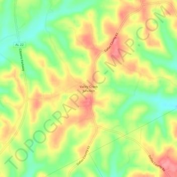
Name: Topografische Karte Valley Creek Junction, Höhe, Relief.
Ort: Valley Creek Junction, Dallas County, Alabama, United States (32.54847 -86.96888 32.58847 -86.92888)
Durchschnittliche Höhe: 115 m
Minimale Höhe: 70 m
Maximale Höhe: 157 m
Andere topografische Karten
Klicken Sie auf eine Karte, um ihre Topografie, ihre Höhe und ihr Relief anzuzeigen.
Selmont–West Selmont
United States > Alabama > Dallas County
Selmont–West Selmont, Dallas County, Alabama, 36702, United States
Durchschnittliche Höhe: 35 m
Elm Bluff
United States > Alabama > Dallas County
Elm Bluff, Dallas County, Alabama, United States
Durchschnittliche Höhe: 88 m
Plantersville
United States > Alabama > Dallas County
Plantersville, Dallas County, Alabama, 36758, United States
Durchschnittliche Höhe: 89 m
Orrville
United States > Alabama > Dallas County > Orrville
Orrville, Dallas County, Alabama, United States
Durchschnittliche Höhe: 57 m
Valley Grande
United States > Alabama > Dallas County > Valley Grande
Valley Grande, Dallas County, Alabama, United States
Durchschnittliche Höhe: 101 m
Sunset Mill Village
United States > Alabama > Dallas County > Selma > Sunset Mill Village
Sunset Mill Village, Selma, Dallas County, Alabama, 36701, United States
Durchschnittliche Höhe: 38 m