
Topografische Karte Château-Renault
Interaktive Karte
Klicken Sie auf die Karte, um die Höhe anzuzeigen.
Château-Renault
Château-Renault is located on the Far-West of the Gâtine Tourangelle plateau, next to the Loir-et-Cher department and at the confluence of two rivers : The Gault and the Brenne. Its Elevation vary between 90 meters and 140 meters on the plateau. The area of the commune is 3.51 square kilometre.
Über diese Karte
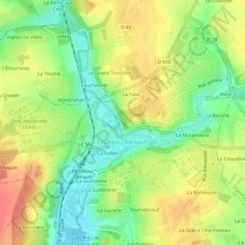
Name: Topografische Karte Château-Renault, Höhe, Relief.
Durchschnittliche Höhe: 112 m
Minimale Höhe: 83 m
Maximale Höhe: 141 m