
Topografische Karte Montes Subiedes
Interaktive Karte
Klicken Sie auf die Karte, um die Höhe anzuzeigen.
Über diese Karte
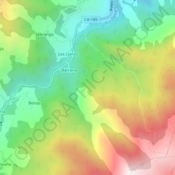
Name: Topografische Karte Montes Subiedes, Höhe, Relief.
Ort: Montes Subiedes, Camaleño, Liébana, Cantabria, 39582, España (43.12243 -4.71877 43.14243 -4.69877)
Durchschnittliche Höhe: 857 m
Minimale Höhe: 459 m
Maximale Höhe: 1.415 m
Andere topografische Karten
Klicken Sie auf eine Karte, um ihre Topografie, ihre Höhe und ihr Relief anzuzeigen.
Pico del Buey
Pico del Buey, Camaleño, Liébana, Cantabria, 39588, España
Durchschnittliche Höhe: 1.462 m