
Topografische Karte Mount Vernon
Interaktive Karte
Klicken Sie auf die Karte, um die Höhe anzuzeigen.
Über diese Karte
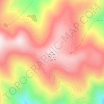
Name: Topografische Karte Mount Vernon, Höhe, Relief.
Durchschnittliche Höhe: 1.460 m
Minimale Höhe: 1.007 m
Maximale Höhe: 1.707 m
Andere topografische Karten
Klicken Sie auf eine Karte, um ihre Topografie, ihre Höhe und ihr Relief anzuzeigen.
Yellowstone River
United States of America > Montana
Yellowstone River, Custer County, Montana, 59301, United States of America
Durchschnittliche Höhe: 720 m
Gardiner
United States of America > Montana > Gardiner
Gardiner, Park County, Montana, United States of America
Durchschnittliche Höhe: 1.931 m
Belgrade
United States of America > Montana > Belgrade
Belgrade, Gallatin County, Montana, 59714, United States of America
Durchschnittliche Höhe: 1.355 m
Waterton-Glacier International Peace Park
United States of America > Montana
Waterton-Glacier International Peace Park, Flathead County, Montana, United States of America
Durchschnittliche Höhe: 1.481 m
Snowden
United States of America > Montana > Snowden
Snowden, Roosevelt County, Montana, United States of America
Durchschnittliche Höhe: 597 m
Belt Butte
United States of America > Montana
Belt Butte, Cascade County, Montana, United States of America
Durchschnittliche Höhe: 1.202 m
McCone County
United States of America > Montana
McCone County, Montana, United States of America
Durchschnittliche Höhe: 761 m
West Glacier
United States of America > Montana > West Glacier
West Glacier, Flathead County, Montana, 59936, United States of America
Durchschnittliche Höhe: 1.201 m
Creston
United States of America > Montana > Creston
Creston, Flathead County, Montana, 59904, United States of America
Durchschnittliche Höhe: 897 m
Saltese
United States of America > Montana > Saltese
Saltese, Mineral County, Montana, United States of America
Durchschnittliche Höhe: 1.259 m
Hirsch
United States of America > Montana > Hirsch
Hirsch, Lockwood, Yellowstone County, Montana, United States of America
Durchschnittliche Höhe: 959 m