
Topografische Karte Lima
Interaktive Karte
Klicken Sie auf die Karte, um die Höhe anzuzeigen.
Über diese Karte
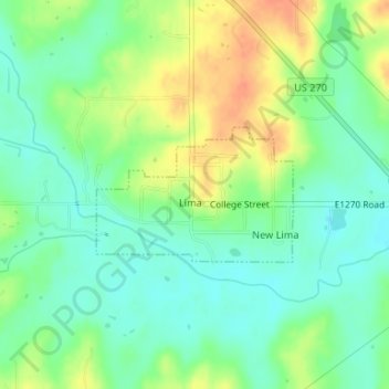
Name: Topografische Karte Lima, Höhe, Relief.
Ort: Lima, Seminole County, Oklahoma, United States (35.16984 -96.60774 35.17921 -96.59097)
Durchschnittliche Höhe: 262 m
Minimale Höhe: 245 m
Maximale Höhe: 286 m
Andere topografische Karten
Klicken Sie auf eine Karte, um ihre Topografie, ihre Höhe und ihr Relief anzuzeigen.
Little
United States > Oklahoma > Seminole County
Little, Seminole County, Oklahoma, United States
Durchschnittliche Höhe: 288 m
Bowlegs
United States > Oklahoma > Seminole County
Bowlegs, Seminole County, Oklahoma, 74830, United States
Durchschnittliche Höhe: 287 m
Cromwell
United States > Oklahoma > Seminole County
Cromwell, Seminole County, Oklahoma, 74837, United States
Durchschnittliche Höhe: 275 m
Wewoka
United States > Oklahoma > Seminole County
Wewoka, Seminole County, Oklahoma, 74884, United States
Durchschnittliche Höhe: 255 m
Sasakwa
United States > Oklahoma > Seminole County > Sasakwa
Sasakwa, Seminole County, Oklahoma, United States
Durchschnittliche Höhe: 259 m
Konawa
United States > Oklahoma > Seminole County
Konawa, Seminole County, Oklahoma, 74849, United States
Durchschnittliche Höhe: 298 m