
Topografische Karte Cape Coral
Interaktive Karte
Klicken Sie auf die Karte, um die Höhe anzuzeigen.
Über diese Karte
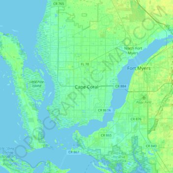
Name: Topografische Karte Cape Coral, Höhe, Relief.
Ort: Cape Coral, Lee County, Florida, 33914-4648, United States (26.44594 -82.14068 26.76594 -81.82068)
Durchschnittliche Höhe: 3 m
Minimale Höhe: -2 m
Maximale Höhe: 13 m
Andere topografische Karten
Klicken Sie auf eine Karte, um ihre Topografie, ihre Höhe und ihr Relief anzuzeigen.
Calusa Land Trust and Nature Preserve of Pine Island
United States > Florida > Lee County > Cape Coral
Calusa Land Trust and Nature Preserve of Pine Island, Cape Coral, Lee County, Florida, United States
Durchschnittliche Höhe: 1 m
Coral Lakes
United States > Florida > Lee County > Cape Coral
Coral Lakes, Cape Coral, Lee County, Florida, 33909, United States
Durchschnittliche Höhe: 6 m
McDonough Canal
United States > Florida > Lee County > Cape Coral
McDonough Canal, Cape Coral, Lee County, Florida, 33991, United States
Durchschnittliche Höhe: 3 m
Sacremento Canal
United States > Florida > Lee County > Cape Coral
Sacremento Canal, Cape Coral, Lee County, Florida, 33904, United States
Durchschnittliche Höhe: 4 m