
Topografische Karte St. Catharines
Klicken Sie auf die Karte, um die Höhe anzuzeigen.
St. Catharines
The most defining transportation icon of St. Catharines is the Welland Canal, a ship canal that runs 43.4 kilometres (27.0 mi), passing through the city. Four of its locks are within city boundaries. The canal allows shipping vessels to traverse the 99.5-metre (326.5 ft) drop in altitude from Lake Erie to Lake Ontario.
Über diese Karte
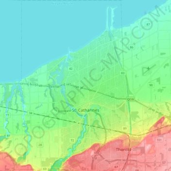
Name: Topografische Karte St. Catharines, Höhe, Relief.
Durchschnittliche Höhe: 103 m
Minimale Höhe: 70 m
Maximale Höhe: 195 m
Andere topografische Karten
Klicken Sie auf eine Karte, um ihre Topografie, ihre Höhe und ihr Relief anzuzeigen.
Stevensville
Canada > Ontario > Niagara Region > Fort Erie > Stevensville
Durchschnittliche Höhe: 178 m
Niagara-on-the-Lake
Canada > Ontario > Niagara Region > Niagara-on-the-Lake
Durchschnittliche Höhe: 82 m
Queenston Heights Park
Canada > Ontario > Niagara Region > Niagara-on-the-Lake > Queenston
Durchschnittliche Höhe: 139 m
Wainfleet Lake Erie Public Access Beach
Canada > Ontario > Niagara Region > Wainfleet
Durchschnittliche Höhe: 175 m