
Topografische Karte Wishaw
Klicken Sie auf die Karte, um die Höhe anzuzeigen.
Über diese Karte
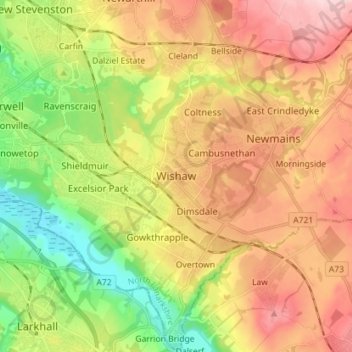
Name: Topografische Karte Wishaw, Höhe, Relief.
Ort: Wishaw, North Lanarkshire, Scotland, ML2 7BL, United Kingdom (55.73435 -3.95841 55.81435 -3.87841)
Durchschnittliche Höhe: 124 m
Minimale Höhe: 22 m
Maximale Höhe: 229 m
Andere topografische Karten
Klicken Sie auf eine Karte, um ihre Topografie, ihre Höhe und ihr Relief anzuzeigen.
Forrestburn Reservoir
United Kingdom > Scotland > North Lanarkshire > Bentfoot
Durchschnittliche Höhe: 231 m
Strathclyde Park
United Kingdom > Scotland > North Lanarkshire > Motherwell
Durchschnittliche Höhe: 44 m
Cumbernauld
United Kingdom > Scotland > North Lanarkshire
Cumbernauld's name probably comes from the Gaelic comar nan allt, meaning "meeting of the burns or streams". There are differing views as to the etymology of this. One theory is that from its high point in the Central Belt, its streams flow both west to the River Clyde and east to the Firth of Forth so…
Durchschnittliche Höhe: 113 m