
Topografische Karte Mora
Interaktive Karte
Klicken Sie auf die Karte, um die Höhe anzuzeigen.
Über diese Karte
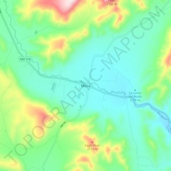
Name: Topografische Karte Mora, Höhe, Relief.
Ort: Mora, Mora County, New Mexico, 87732, United States (35.93415 -105.36994 36.01415 -105.28994)
Durchschnittliche Höhe: 2.297 m
Minimale Höhe: 2.152 m
Maximale Höhe: 2.697 m
Mora or Santa Gertrudis de lo de Mora is a census-designated place in, and the county seat of, Mora County, New Mexico. It is located about halfway between Las Vegas and Taos on Highway 518, at an altitude of 7,180 feet. The Republic of Texas performed a semi-official raid on Mora in 1843. Two short battles of the Mexican–American War were fought in Mora in 1847, where U.S. troops eventually defeated the Hispano and Puebloan militia, effectively ending the Taos Revolt in the Mora Valley. The latter battle destroyed most of the community, necessitating its re-establishment.
Andere topografische Karten
Klicken Sie auf eine Karte, um ihre Topografie, ihre Höhe und ihr Relief anzuzeigen.
Lucero
United States > New Mexico > Mora County
Lucero, Mora County, New Mexico, United States
Durchschnittliche Höhe: 2.230 m
Pecos Wilderness
United States > New Mexico > Mora County
Pecos Wilderness, Mora County, New Mexico, United States
Durchschnittliche Höhe: 2.887 m
Cleveland
United States > New Mexico > Mora County
Cleveland, Mora County, New Mexico, 87715, United States
Durchschnittliche Höhe: 2.312 m
Ocate
United States > New Mexico > Mora County
Ocate, Mora County, New Mexico, 87734, United States
Durchschnittliche Höhe: 2.235 m
Vallecitos
United States > New Mexico > Mora County
Vallecitos, Mora County, New Mexico, 87715, United States
Durchschnittliche Höhe: 2.454 m