Geolokalisieren

Topografische Karte Bryan

Interaktive Karte

Klicken Sie auf die Karte, um die Höhe anzuzeigen.

Über diese Karte

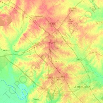
Name: Topografische Karte Bryan, Höhe, Relief.

Ort: Bryan, Brazos County, Texas, United States (30.58460 -96.45925 30.73152 -96.24589)

Durchschnittliche Höhe: 94 m

Minimale Höhe: 57 m

Maximale Höhe: 123 m

Andere topografische Karten

Klicken Sie auf eine Karte, um ihre Topografie, ihre Höhe und ihr Relief anzuzeigen.

John Crompton Park

United States > Texas > Brazos County > College Station

John Crompton Park, Fox Run Condominiums, College Station, Brazos County, Texas, 77840, United States

Durchschnittliche Höhe: 96 m

Bryan

United States > Texas > Brazos County > Bryan

Bryan, Brazos County, Texas, 77803, United States

Durchschnittliche Höhe: 89 m

College Station

United States > Texas > Brazos County

College Station, Brazos County, Texas, United States

Durchschnittliche Höhe: 87 m

Wixon Valley

United States > Texas > Brazos County

Wixon Valley, Brazos County, Texas, United States

Durchschnittliche Höhe: 99 m

College Station

United States > Texas > Brazos County > College Station

College Station, Brazos County, Texas, 77845-5357, United States

Durchschnittliche Höhe: 82 m

Moore

United States > Texas > Brazos County > Wixon Valley

Moore, Wixon Valley, Brazos County, Texas, 77808, United States

Durchschnittliche Höhe: 101 m

Carter Lake

United States > Texas > Brazos County > College Station

Carter Lake, College Station, Brazos County, Texas, United States

Durchschnittliche Höhe: 77 m