
Topografische Karte Orcas Island
Interaktive Karte
Klicken Sie auf die Karte, um die Höhe anzuzeigen.
Über diese Karte
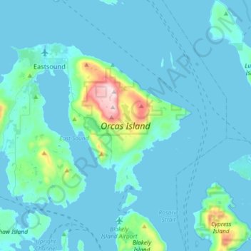
Name: Topografische Karte Orcas Island, Höhe, Relief.
Durchschnittliche Höhe: 59 m
Minimale Höhe: -1 m
Maximale Höhe: 723 m
Mount Constitution (elevation 2409 feet/734 meters) is the highest point in the San Juan islands. The mountain is part of Moran State Park, the largest public recreation area in the San Juan Islands, and the largest State Park in Washington. Moran State Park encompasses over 5,000 acres (2,000 ha) of woodland and has several lakes, including Cascade Lake, Mountain Lake, Summit Lake, and Twin Lakes, and numerous waterfalls.