
Topografische Karte Newland
Interaktive Karte
Klicken Sie auf die Karte, um die Höhe anzuzeigen.
Über diese Karte
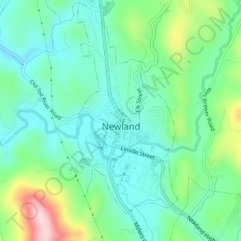
Name: Topografische Karte Newland, Höhe, Relief.
Ort: Newland, Avery County, North Carolina, United States (36.07748 -81.93346 36.10475 -81.91943)
Durchschnittliche Höhe: 1.140 m
Minimale Höhe: 1.074 m
Maximale Höhe: 1.321 m
At an elevation of 3,621 feet or 1,104 metres, it is the highest county seat in the Eastern United States (based on elevations in the USGS database).
Andere topografische Karten
Klicken Sie auf eine Karte, um ihre Topografie, ihre Höhe und ihr Relief anzuzeigen.
Mount Gilead
United States > North Carolina > Avery County
Mount Gilead, Avery County, North Carolina, United States
Durchschnittliche Höhe: 891 m
Beech Mountain
United States > North Carolina > Avery County > Beech Mountain
Beech Mountain, Avery County, North Carolina, 28604, United States
Durchschnittliche Höhe: 1.433 m
Sugar Mountain
United States > North Carolina > Avery County > Sugar Mountain
Sugar Mountain, Avery County, North Carolina, United States
Durchschnittliche Höhe: 1.385 m
Banner Elk
United States > North Carolina > Avery County
Banner Elk, Avery County, North Carolina, United States
Durchschnittliche Höhe: 1.165 m