
Topografische Karte Kosñipata
Interaktive Karte
Klicken Sie auf die Karte, um die Höhe anzuzeigen.
Über diese Karte
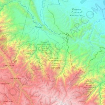
Name: Topografische Karte Kosñipata, Höhe, Relief.
Ort: Kosñipata, Provincia de Paucartambo, Cuzco, Perú (-13.52671 -71.92120 -12.70006 -71.06418)
Durchschnittliche Höhe: 1.996 m
Minimale Höhe: 324 m
Maximale Höhe: 5.502 m
Andere topografische Karten
Klicken Sie auf eine Karte, um ihre Topografie, ihre Höhe und ihr Relief anzuzeigen.
Pillcopata
Perú > Cuzco > Kosñipata > Pillcopata
Pillcopata, Kosñipata, Provincia de Paucartambo, Cuzco, Perú
Durchschnittliche Höhe: 618 m