
Topografische Karte Pansol
Interaktive Karte
Klicken Sie auf die Karte, um die Höhe anzuzeigen.
Über diese Karte
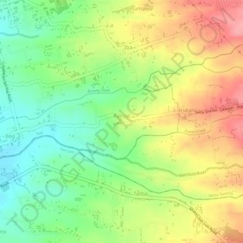
Name: Topografische Karte Pansol, Höhe, Relief.
Ort: Pansol, Taal, Batangas, Calabarzon, 4208, Philippines (13.86023 120.93046 13.86856 120.94485)
Durchschnittliche Höhe: 69 m
Minimale Höhe: 13 m
Maximale Höhe: 127 m
Andere topografische Karten
Klicken Sie auf eine Karte, um ihre Topografie, ihre Höhe und ihr Relief anzuzeigen.
Carasuche
Philippines > Batangas > Taal
Carasuche, Taal, Batangas, Calabarzon, 4208, Philippines
Durchschnittliche Höhe: 93 m
Bolbok
Philippines > Batangas > Taal
Bolbok, Taal, Batangas, Calabarzon, 4208, Philippines
Durchschnittliche Höhe: 117 m
Cawit
Philippines > Batangas > Taal > Cawit
Cawit, Taal, Batangas, Calabarzon, 4208, Philippines
Durchschnittliche Höhe: 39 m
Poblacion 13
Philippines > Batangas > Taal > Poblacion 13
Poblacion 13, Taal, Batangas, Calabarzon, 4208, Philippines
Durchschnittliche Höhe: 38 m