
Topografische Karte Noatak
Interaktive Karte
Klicken Sie auf die Karte, um die Höhe anzuzeigen.
Über diese Karte
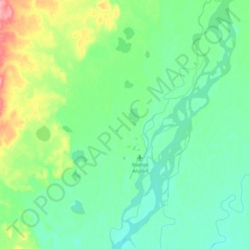
Name: Topografische Karte Noatak, Höhe, Relief.
Ort: Noatak, Northwest Arctic, Alaska, United States (67.52037 -163.25985 67.64493 -162.93130)
Durchschnittliche Höhe: 31 m
Minimale Höhe: 12 m
Maximale Höhe: 98 m
Andere topografische Karten
Klicken Sie auf eine Karte, um ihre Topografie, ihre Höhe und ihr Relief anzuzeigen.
Buckland
United States > Alaska > Northwest Arctic
Buckland, Northwest Arctic, Alaska, 99727, United States
Durchschnittliche Höhe: 9 m
Kotzebue
United States > Alaska > Northwest Arctic
Kotzebue, Northwest Arctic, Alaska, United States
Durchschnittliche Höhe: 9 m
Red Dog Mine
United States > Alaska > Northwest Arctic
Red Dog Mine, Northwest Arctic, Alaska, United States
Durchschnittliche Höhe: 315 m
Mount Igikpak
United States > Alaska > Northwest Arctic
Mount Igikpak, Northwest Arctic, Alaska, United States
Durchschnittliche Höhe: 1.728 m