
Spenden
Rüsten Sie sich für Ihr nächstes Abenteuer:
Als Amazon-Partner verdient diese Website an qualifizierten Käufen, ohne dass Ihnen zusätzliche Kosten entstehen.
Topografische Karte Pinos Altos
Klicken Sie auf die Karte, um die Höhe anzuzeigen.
Spenden
Rüsten Sie sich für Ihr nächstes Abenteuer:
Als Amazon-Partner verdient diese Website an qualifizierten Käufen, ohne dass Ihnen zusätzliche Kosten entstehen.
Über diese Karte
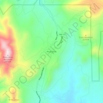
Name: Topografische Karte Pinos Altos, Höhe, Relief.
Durchschnittliche Höhe: 2.142 m
Minimale Höhe: 1.983 m
Maximale Höhe: 2.470 m
Spenden
Rüsten Sie sich für Ihr nächstes Abenteuer:
Als Amazon-Partner verdient diese Website an qualifizierten Käufen, ohne dass Ihnen zusätzliche Kosten entstehen.
Andere topografische Karten
Klicken Sie auf eine Karte, um ihre Topografie, ihre Höhe und ihr Relief anzuzeigen.
Silver City
United States > New Mexico > Grant County
During the period from 1901 to 1964 when readings were taken at the city center (which is cooler and wetter than outlying and lower-elevation districts nearby), the coldest temperature recorded was −13 °F (−25 °C) on January 11, 1962, and the hottest 105 °F (40.6 °C) on July 5, 1901. The coldest month…
Durchschnittliche Höhe: 1.850 m
Bayard
United States > New Mexico > Grant County
Bayard is located in the southern foothills of the Pinos Altos Range and Mogollon Mountains in the southwestern portion of New Mexico and situated east of the Continental Divide at an elevation of approximately 5,800 feet (1,800 m). Gila National Forest lies north from here. A semi-arid desert of predominantly…
Durchschnittliche Höhe: 1.816 m
Silver City
United States > New Mexico > Grant County
During the period from 1901 to 1964, when readings were taken at the city center (which is cooler and wetter than outlying and lower-elevation districts nearby), the coldest temperature recorded was −13 °F (−25 °C) on January 11, 1962, and the hottest 105 °F (40.6 °C) on July 5, 1901. The coldest month…
Durchschnittliche Höhe: 1.851 m
Spenden
Rüsten Sie sich für Ihr nächstes Abenteuer:
Als Amazon-Partner verdient diese Website an qualifizierten Käufen, ohne dass Ihnen zusätzliche Kosten entstehen.