
Topografische Karte Sasolburg
Interaktive Karte
Klicken Sie auf die Karte, um die Höhe anzuzeigen.
Sasolburg
Sasolburg is at a high altitude with a fairly dry climate and large seasonal temperature variation. It is situated on the banks of the Vaal River, which separates the Free State from the former Transvaal Province, and is not far from the Vaal Dam where excellent windsurfing spots can be found.
Über diese Karte
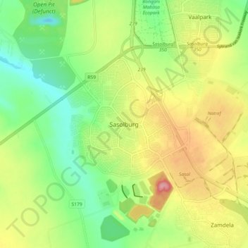
Name: Topografische Karte Sasolburg, Höhe, Relief.
Durchschnittliche Höhe: 1.469 m
Minimale Höhe: 1.418 m
Maximale Höhe: 1.536 m
Andere topografische Karten
Klicken Sie auf eine Karte, um ihre Topografie, ihre Höhe und ihr Relief anzuzeigen.
Vaal Dam
South Africa > Free State > Fezile Dabi District Municipality > Metsimaholo Local Municipality > Deneysville
Durchschnittliche Höhe: 1.481 m
Vaal Dam
South Africa > Free State > Fezile Dabi District Municipality > Metsimaholo Local Municipality > Deneysville
Durchschnittliche Höhe: 1.481 m
Metsimaholo Ward 19
South Africa > Free State > Fezile Dabi District Municipality > Metsimaholo Local Municipality
Durchschnittliche Höhe: 1.466 m
Vaal Dam
South Africa > Free State > Fezile Dabi District Municipality > Metsimaholo Local Municipality > Deneysville
Durchschnittliche Höhe: 1.481 m
Vaal Dam
South Africa > Free State > Fezile Dabi District Municipality > Metsimaholo Local Municipality > Deneysville
Durchschnittliche Höhe: 1.481 m