
Topografische Karte Garcia Moreno
Interaktive Karte
Klicken Sie auf die Karte, um die Höhe anzuzeigen.
Über diese Karte
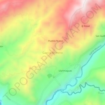
Name: Topografische Karte Garcia Moreno, Höhe, Relief.
Ort: Garcia Moreno, García Moreno, Cotacachi, Imbabura, Ecuador (0.21226 -78.64799 0.25226 -78.60799)
Durchschnittliche Höhe: 1.302 m
Minimale Höhe: 904 m
Maximale Höhe: 1.743 m
Andere topografische Karten
Klicken Sie auf eine Karte, um ihre Topografie, ihre Höhe und ihr Relief anzuzeigen.
San Antonio de Pucara
Ecuador > Imbabura > Cotacachi > Apuela
San Antonio de Pucara, Apuela, Cotacachi, Imbabura, Ecuador
Durchschnittliche Höhe: 1.875 m
Las Golondrinas
Ecuador > Imbabura > Cotacachi > Las Golondrinas
Las Golondrinas, Cotacachi, Imbabura, 900004, Ecuador
Durchschnittliche Höhe: 240 m
Cerro Chimborazo
Ecuador > Imbabura > Cotacachi > Imantag
Cerro Chimborazo, Imantag, Cotacachi, Imbabura, Ecuador
Durchschnittliche Höhe: 3.931 m
Rio Intag
Ecuador > Imbabura > Cotacachi > Garcia Moreno
Rio Intag, Garcia Moreno, García Moreno, Cotacachi, Imbabura, 100305, Ecuador
Durchschnittliche Höhe: 1.680 m
Cerro El Mirrador
Ecuador > Imbabura > Cotacachi
Cerro El Mirrador, García Moreno, Cotacachi, Imbabura, Ecuador
Durchschnittliche Höhe: 1.898 m
Quebrada Santa Rosa
Ecuador > Imbabura > Cotacachi
Quebrada Santa Rosa, Cotacachi, Imbabura, Ecuador
Durchschnittliche Höhe: 3.405 m
Ugshapungo
Ecuador > Imbabura > Cotacachi > Quiroga
Ugshapungo, Quiroga, Cotacachi, Imbabura, Ecuador
Durchschnittliche Höhe: 3.122 m