
Topografische Karte Monte Giove
Interaktive Karte
Klicken Sie auf die Karte, um die Höhe anzuzeigen.
Über diese Karte
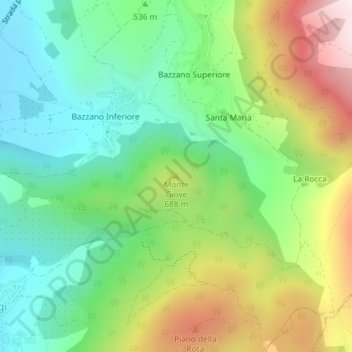
Name: Topografische Karte Monte Giove, Höhe, Relief.
Ort: Monte Giove, Spoleto, Perugia, Umbria, 06049, Italy (42.77184 12.79584 42.77194 12.79594)
Durchschnittliche Höhe: 568 m
Minimale Höhe: 298 m
Maximale Höhe: 1.038 m
Andere topografische Karten
Klicken Sie auf eine Karte, um ihre Topografie, ihre Höhe und ihr Relief anzuzeigen.
Sant'Anastasio
Italy > Umbria > Perugia > Spoleto > San Venanzo
Sant'Anastasio, San Venanzo, Spoleto, Perugia, Umbria, 06049, Italy
Durchschnittliche Höhe: 283 m
Monte Acuto
Italy > Umbria > Perugia > Spoleto
Monte Acuto, Spoleto, Perugia, Umbria, 06049, Italy
Durchschnittliche Höhe: 717 m
Montemartano
Italy > Umbria > Perugia > Spoleto
Montemartano, Spoleto, Perugia, Umbria, 06049, Italy
Durchschnittliche Höhe: 674 m