
Topografische Karte Muzon
Interaktive Karte
Klicken Sie auf die Karte, um die Höhe anzuzeigen.
Über diese Karte
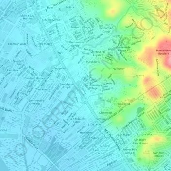
Name: Topografische Karte Muzon, Höhe, Relief.
Ort: Muzon, Taytay, Rizal, Calabarzon, 1920, Philippines (14.53343 121.13547 14.55844 121.16116)
Durchschnittliche Höhe: 28 m
Minimale Höhe: -3 m
Maximale Höhe: 131 m
The shape of Taytay is rectangular – trapezoidal with gently hilly rolling terrain on its eastern side while relatively flat on its south-western side, including the poblacion. The municipality's highest elevation ranges from 200 to 255 meters which is situated along the inner north-eastern hills of Barangay Dolores, alongside the Antipolo Boundary. Its lowest points are from 5 to 20 meters along the southern portion of Barangay San Juan and Muzon towards Laguna Lake.
Andere topografische Karten
Klicken Sie auf eine Karte, um ihre Topografie, ihre Höhe und ihr Relief anzuzeigen.
Havila
Philippines > Rizal > Taytay
Havila, Taytay, Rizal, Calabarzon, 1880, Philippines
Durchschnittliche Höhe: 106 m
Manggahan Floodway
Philippines > Rizal > Taytay
Manggahan Floodway, Taytay, Eastern Manila District, Rizal, Calabarzon, 1983, Philippines
Durchschnittliche Höhe: 21 m
Dolores
Philippines > Rizal > Taytay
Dolores, Taytay, Rizal, Calabarzon, 1920, Philippines
Durchschnittliche Höhe: 33 m
San Isidro
Philippines > Rizal > Taytay > San Isidro
San Isidro, Taytay, Rizal, Calabarzon, Philippines
Durchschnittliche Höhe: 46 m
Cuatro Cantos
Philippines > Rizal > Taytay > Cuatro Cantos
Cuatro Cantos, Taytay, Rizal, Calabarzon, 1920, Philippines
Durchschnittliche Höhe: 23 m
Santa Ana
Philippines > Rizal > Taytay
Santa Ana, Taytay, Rizal, Calabarzon, 1920, Philippines
Durchschnittliche Höhe: 9 m
San Juan
Philippines > Rizal > Taytay
San Juan, Taytay, Rizal, Calabarzon, 1920, Philippines
Durchschnittliche Höhe: 24 m