
Topografische Karte Gorontalo
Interaktive Karte
Klicken Sie auf die Karte, um die Höhe anzuzeigen.
Über diese Karte
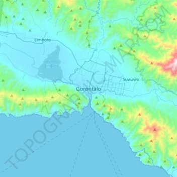
Name: Topografische Karte Gorontalo, Höhe, Relief.
Ort: Gorontalo, Sulawesi, Indonesia (0.37844 122.89950 0.69844 123.21950)
Durchschnittliche Höhe: 147 m
Minimale Höhe: 0 m
Maximale Höhe: 1.467 m
Gorontalo shares its borders with Bone Bolango Regency (to the north and east), Tomini Gulf (to the south), and Gorontalo Regency (to the west). Its elevation does not rise above 500 metres or 1,640 feet above mean sea level and the average temperature is 26.5 °C or 79.7 °F.
Andere topografische Karten
Klicken Sie auf eine Karte, um ihre Topografie, ihre Höhe und ihr Relief anzuzeigen.
Monas
Indonesia > Gorontalo > Gorontalo Utara
Monas, Gorontalo Utara, Gorontalo, Sulawesi, Indonesia
Durchschnittliche Höhe: 6 m
Tanjung Harapan
Indonesia > Gorontalo > Tanjung Harapan
Tanjung Harapan, Gorontalo, Indonesia
Durchschnittliche Höhe: 58 m