
Topografische Karte Bexar
Interaktive Karte
Klicken Sie auf die Karte, um die Höhe anzuzeigen.
Über diese Karte
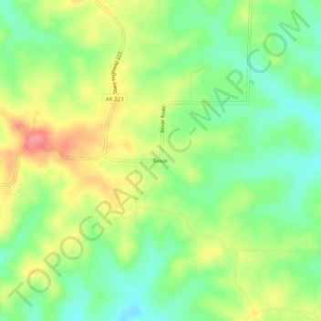
Name: Topografische Karte Bexar, Höhe, Relief.
Ort: Bexar, Fulton County, Arkansas, 72515, United States (36.26673 -92.01571 36.30673 -91.97571)
Durchschnittliche Höhe: 265 m
Minimale Höhe: 227 m
Maximale Höhe: 315 m
Andere topografische Karten
Klicken Sie auf eine Karte, um ihre Topografie, ihre Höhe und ihr Relief anzuzeigen.
Salem
United States > Arkansas > Fulton County
Salem, Fulton County, Arkansas, United States
Durchschnittliche Höhe: 224 m
Gepp
United States > Arkansas > Fulton County
Gepp, Fulton County, Arkansas, 72538, United States
Durchschnittliche Höhe: 242 m
Sturkie
United States > Arkansas > Fulton County
Sturkie, Fulton County, Arkansas, 72578, United States
Durchschnittliche Höhe: 232 m
Camp
United States > Arkansas > Fulton County
Camp, Fulton County, Arkansas, 72520, United States
Durchschnittliche Höhe: 215 m
Saddle
United States > Arkansas > Fulton County
Saddle, Fulton County, Arkansas, United States
Durchschnittliche Höhe: 173 m
Viola
United States > Arkansas > Fulton County
Viola, Fulton County, Arkansas, 72583, United States
Durchschnittliche Höhe: 268 m
Mammoth Spring
United States > Arkansas > Fulton County
Mammoth Spring, Fulton County, Arkansas, United States
Durchschnittliche Höhe: 186 m
Glencoe
United States > Arkansas > Fulton County
Glencoe, Fulton County, Arkansas, 72539, United States
Durchschnittliche Höhe: 233 m
Salem
United States > Arkansas > Fulton County > Salem
Salem, Fulton County, Arkansas, 72576, United States
Durchschnittliche Höhe: 231 m
Elizabeth
United States > Arkansas > Fulton County
Elizabeth, Fulton County, Arkansas, United States
Durchschnittliche Höhe: 233 m